Young-Earth Creationism
and the
Geology of the Grand Canyon
Text and Photographs by Jon Woolf
Part 2: The Grand Canyon
So, we've looked at how the Colorado Plateau was formed, and it certainly appears that the orthodox theory explains it much better than the young-Earth theory does. Now we can go on to Question 2: How was the Grand Canyon formed?
Again, the best way to start the answer is by first clearly defining the question. So just what is this "Grand Canyon" that we're trying to explain? The Grand Canyon of the Colorado River is an enormous gash cut through the southern side of the Colorado Plateau, some distance south of the highest part of the Kaibab Uplift. Today the Canyon forms a major part of the pathway traveled by the Colorado River in descending from the Rocky Mountains to the Gulf of California. Officially, the Grand Canyon extends 277 miles, from Lee's Ferry just below Glen Canyon Dam to Grand Wash Cliffs, a few miles above Lake Meade. At its deepest the Grand Canyon is a bit more than a mile deep from the North Rim to the river; at its widest it's some eighteen miles from Rim to Rim as the crow flies, much longer by trail. From Glen Canyon Dam to Lake Meade the river descends 2,000 feet. Before Glen Canyon Dam was built, the Colorado River's flow through the Canyon could reach 200,000 cubic feet per second (cfs) in heavy floods.
The Grand Canyon's basic appearance is what geologists call a dendritic drainage pattern. This pattern is usually produced by a medium to high altitude mountain river valley, which descends relatively rapidly, resulting in a fast flow rate and vigorous cutting downward into the terrain. In the eastern part of the Canyon, the river wanders within a relatively shallow, broad bed between widely spread canyon walls. There are occasional sharp bends and a few meanders here and there. Point bars form at these sharp bends, in a way familiar to anyone who has some knowledge of rivers and how they work.
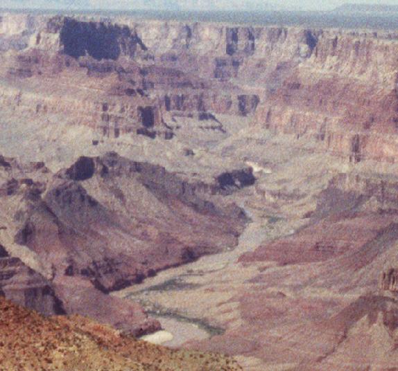
Figure 2.1: the Colorado River's course in the eastern Grand Canyon, near its confluence with the Little Colorado. At this point, near Desert View, the river flows through and over rocks of the Grand Canyon Supergroup.
Farther west, as the river descends into Granite Gorge through the Vishnu Schist, it changes its character, becoming much straighter. Granite Gorge is a classic example of the type of deep-V river valley formed by a river that is downcutting rapidly. This immediately suggests two questions. First, how could any river cut so deeply into such very hard rock? Second, if the canyon is cut this deeply here, why is it not deeper upstream? What's different between the eastern and western Canyons, such that the river cut so deeply in the west and not in the east?
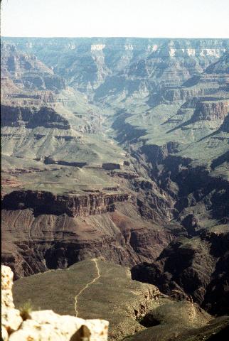
Figure 2.2: Bright Angel Canyon, as seen from Maricopa Point on the West Rim Drive. In the distance you can make out many of the layers of the Colorado Plateau rocks: the Kaibab Limestone on the Rim, the vivid gray-white Coconino Sandstone, the sheer vertical drop of the Redwall Limestone, and so on. On the near side of the Canyon, the Bright Angel Trail snakes out across the Tonto Platform. Bright Angel Canyon follows the trend of Bright Angel Fault, a major fault line in the Colorado Plateau.
Side-canyons enter the main canyon every few miles, where streams, creeks, and washes find their way down from the Rim and into the Canyon. Bright Angel Canyon is one of the larger ones, and is more or less typical. Almost a miniature of the Grand Canyon itself, it descends from the North Rim to the Inner Gorge along a meandering path between walls of rock, cutting through the entire Paleozoic sequence, some of the Unkar Group, and down into the Vishnu Group. It should be obvious that any theory which claims to explain how the main canyon formed also needs to account for the tributary canyons like Bright Angel Canyon. That includes explaining how they can trend north and south, instead of the main canyon's east-west trend, and still cut the rocks the same way and show basically the same appearance.
Within the Canyon, more than seventy whitewater rapids, some quite violent, punctuate the river's course. Rock debris is eroded away from the Canyon walls by mudflows, water, and other means, then falls, rolls, or washes downhill until it reaches the river. Most of the debris finds its way down by means of the many side-canyons, so most of the rapids occur at the mouths of the side-canyons, where alluvial fans of debris reach out into the main river.
Within the wider parts of the Canyon, there are many tall buttes which stand alone, isolated from both the North and South Rims. Most of them are on the north side of the river, an interesting little fact to which we'll return later. The buttes and mesas are clearly cut from the same rock as the Canyon itself is. Various features make it clear that these buttes were once part of the North Rim, but erosion carved away rock from all around them and left them isolated. Many of these buttes are named after ancient gods from various peoples: the Isis Temple, the Vishnu Temple, Vulcan's Throne, and so on.
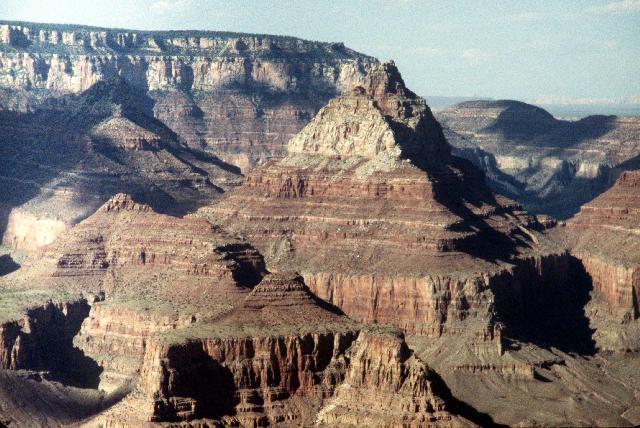
Figure 2.3: The gigantic butte known as the Vishnu Temple, as seen from Grandview Point. The temple itself is carved from the Coconino Sandstone. Below it you can see the Hermit Formation, Supai Group, and Redwall Limestone. All around the temple, other smaller buttes have also been carved from the rock.
As stated previously, in the western Grand Canyon you can find the remnants of more than a hundred and fifty lava flows from the Kaibab Volcanic Field cascading over the North Rim and down into the canyon. At least a dozen of these flows definitely dammed the river for some period of time. A lake formed upstream of each dam, which took some time to fill with water and more time to fill with sediment. When each lake had filled completely with sediment, the water could flow unimpeded again, and rapidly eroded a new river channel through the remnants of the lava dam. Some of these dam-formed lakes were larger than the modern manmade reservoirs along the river, such as Lake Powell upstream of the Canyon and Lake Mead downstream of it. When these dams were finally breached and the lakes drained, it must have resulted in a tremendous rush of water down the Canyon.
Geologists can use the remnants of each lava dam as a basis for estimating how high the whole dam was and what volume of lava it contained. Hydrologists can then use the known rates of flow for the Colorado River to estimate how long it would have taken each dam-formed lake to fill with water and then with sediment. Here are the numbers they got:
| Dam Name | Volume (mi^3) | Height Above River (Feet) | Time to Fill with Water (Days) | Time to Fill with Sediment (Years) |
|---|---|---|---|---|
| Prospect | 4.0 | 2330 | 8400 | 3018 |
| Ponderosa | 2.5 | 1130 | 547 | 163 |
| Toroweap | 3.7 | 1443 | 956 | 345 |
| Esplanade | 1.8 | 960 | 287 | 92 |
| Buried Canyon | 1.7 | 850 | 231 | 87 |
| Whitmore | 3.0 | 900 | 240 | 88 |
| "D" Flows | 1.1 | 635 | 87 | 31 |
| Lava Falls | 1.2 | 600 | 86 | 30 |
| Black Ledge | 2.1 | 373 | 17 | 7 |
| Gray Ledge | 0.3 | 203 | 2 | 0.86 |
| Layered Dbs. | 0.3 | 298 | 8 | 3 |
| Massive Dbs. | 0.2 | 226 | 5 | 1.4 |
Source: "Late Cenozoic Lava Dams in the Western Grand Canyon," W. K. Hamblin, Ch. 17 of GRAND CANYON GEOLOGY. |
||||
These numbers can tell us several things, but one point seems to stand out. The aggregate sediment fill times (the total of the right-most column) represent more than 3800 years worth of sediment load for the Colorado River at its current flow level. Either the flow of water and sediment was much greater in the past, or these dams are a lot more than a couple of thousand years old.
Another curious fact about the lava dams: after each one was breached, the renewed flow of water eroded away almost all of the basaltic dam material, but very little of the harder Vishnu and Zoroaster rocks that form the wall of the Inner Gorge. The dams may have failed catastrophically, or they may have been gradually worn away after the water filled up behind them. In either case, the renewed water flow was sufficient to erode most of the basalt dams, but not adequate to cut any further into the Vishnu rock. Again there's an indication that something fundamentally different happened here at some time, and that something other than the ordinary river flow was responsible for cutting Granite Gorge into the Vishnu and Zoroaster rocks.
One last point needs mentioning: The Colorado Plateau today is a high-altitude desert. It gets very little annual rainfall, and what it does get tends to come in sudden cloudbursts that cause massive flash flooding. These floods can cause enormous debris flows, many cubic feet of rock, sand, and soil tumbling down the canyon's side and into the river below, adding to existing rapids or forming new ones. At such times, when the river is carrying a heavy load of sediment, it can erode away a lot of rock in relatively little time.
Well, that's that: a simple look at the geology of the Canyon itself. These are the facts that need to be accounted for by any theory that claims to explain how the Grand Canyon formed.
The Creationist Theory
Again, the best source on the young-Earth Creationist view of the Grand Canyon's formation is Austin's book GRAND CANYON: MONUMENT TO CATASTROPHE. Austin's preferred scenario for the Canyon's formation is his "Breached Dam Theory." In this scenario, after the Flood drained off three huge lakes formed north and east of what is today the Grand Canyon: Vernal Lake far to the north, in east-central Utah; Canyonlands Lake, which covered almost half of what is today the upper Colorado River drainage from Marble Canyon to Grand Junction; and Hopi Lake, south of Canyonlands and arching south and east toward the New Mexico border, very roughly the area that is covered today by the Painted Desert. Each of these lakes was formed by water accumulation behind large natural dams that formed as part of the Plateau uplift.
Natural erosion eventually breached all three of these dams. The Hopi Lake dam was breached first, generating a huge flow of water which formed the canyon of the Little Colorado River and began forming the Grand Canyon. Canyonlands Lake followed, pouring even more water through the Canyon and doing the majority of the erosion and downcutting in the Canyon. To the north, Vernal Lake's breaching formed the canyons of the Green River.
To support this view, Austin argues by analogy with two undisputed cases of rapid erosion by massive, sudden flooding. First is the Channeled Scablands of eastern Washington state. The Scablands are generally considered to be the result of massive, catastrophic flooding from the breach of a giant prehistoric lake that filled much of westernmost Montana. This lake was dammed by ice during the Ice Age; when the ice retreated and the dam burst, a giant rush of lakewater raced across central Idaho and into the Scablands. When the Scablands are viewed from high altitude, there is no mistaking their appearance: they are indeed the remnants of a gigantic flash flood, with braided streams, sandbars, coulees, and streambed ripples. Similar features can be seen in many small woodland streams. The only difference is the scale: the Scablands coulees are hundreds of feet high, and the streambed ripples are hundreds of feet long and dozens of feet high.
Austin's second example is the 'Little Grand Canyon of the Toutle River,' a deep-cut gorge along the North Fork of the Toutle River, which flows out of Spirit Lake and through the valley just north of Mount St. Helens. When the volcano erupted on May 18th 1980, the giant lateral blast buried the valley and the headwater-streams under many feet of mud and ash. In the months and years that followed, new mudflows combined with the streams to cut a series of canyons into the deep ash deposits in the valley.
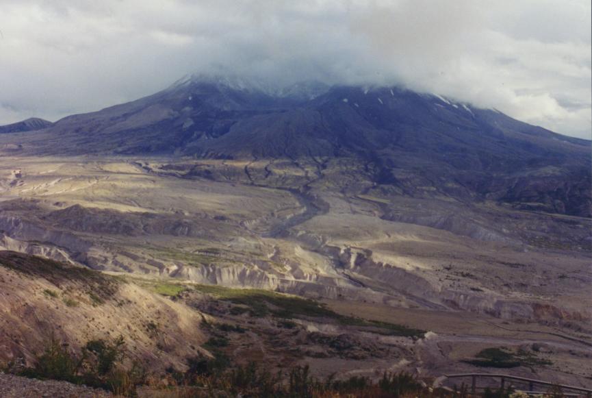
Figure 2.5: The valley of the North Fork Toutle River below Mount St. Helens, viewed from Johnston Ridge directly to the south. Note the deep-cut canyons in the foreground, and the others that snake away northward toward the mountain. The dirty gray/tan material that these streams flow over and through is all ash and mud left by the May 18th, 1980 eruption.
Going on, Austin points out that "many of the valleys upstream from the Grand Canyon have rather sluggish streams positioned on very broad flood plains. These streams and rivers appear 'underfit.' The present discharge rates are insufficient to modify significantly these floodplains." He goes on to speculate that the valleys may have instead been cut by a single episode of rapid, catastrophic drainage, such as he thinks occurred when the lakes were breached.
Austin explains the huge semicircular amphitheaters that mark the Canyon walls as "sapping structures" generated by mass wastage after water erosion weakened the rock.
Austin also says that the amount of talus (debris from erosion of cliffs) present in the Canyon isn't enough to support a gradual-erosion view of the Canyon. If the Canyon was millions of years old as orthodox geology says, there should be a lot more talus. As evidence for this he offers a photograph (Figure 5.21, p. 101 of his book) which according to the caption shows a noticeable lack of talus buildup at the base of the pictured cliffs.
In short, Austin argues that the orthodox explanations for the Canyon do not (pardon the pun) hold water, and the creationist, catastrophic explanation makes much more sense.
The Conventional Theory
Orthodox geology has no definite answer to the question of how the Grand Canyon formed. The best current idea is that the current course of the Colorado River is a result of "stream piracy" on a massive scale. "Stream piracy" is the geological term for a situation where a stream eroding headward from its current course cuts through the high ground controlling a second river's flow. The second river's water is then diverted into the first river, and the lower course of the second river dries up.
The current Colorado River course is considered to be the result of headward erosion and stream piracy simply because no one can figure out any other way for it to have been cut the way it was and in the place it was. Remember, the Canyon is not at the top of the Kaibab Uplift, nor around its base, but cuts through the southern slope. And it doesn't flow downslope; if it did, it would flow south, not west. The Colorado River's bed cuts laterally across the entire Kaibab Uplift, in a way that simply makes no sense if the river was eroded in the more common way from headwaters down. Therefore it must be the result of some other process. And the only one that fits is headward erosion.
Even having reached that conclusion, the history of the Colorado is complicated and difficult to unravel. There is no sign of any river where the lower Colorado currently lies before about five to eight million years ago. It's also been difficult to find the exact course of the ancestral upper Colorado. The best idea anyone has suggested is that the upper (eastern) part of the Canyon is much older than the lower (western) Canyon, and the upper Canyon was cut by a river that flowed southeast until somewhere in the central to western Canyon region, where it turned northwest toward an as-yet-unknown destination. Around five or six million years ago, rifting activity opened the Gulf of California and began forming the Basin and Range province west of the Kaibab Uplift. As a result of this activity, a new river formed south of the Basin and Range. This eroded its way headward into the Kaibab Uplift and eventually intersected with and stole the water from the old river, creating the modern Colorado River. This also means that the lower Grand Canyon is no more than six million years old, and the river has cut its deep V-shaped valley into the hard rock of the Inner Gorge in that time.
Such is the explanation for the Colorado River. But what explains the rest of the Canyon? Surely the river couldn't have eroded rock thousands of feet above its current bed! So what formed the temples, buttes, mesas, and so on?
"Mass wasting" is a general geological term for massive sudden movements of rock and soil. It includes things like rockslides, cliff collapses, breakaways, and mudflows. Mass wastage is common in the Grand Canyon. Many mass-wasting events are due ultimately to the simple fact that the shales in the Upper Canyon wall erode faster than the limestones and sandstones do. So it's not unusual to find a section of, say, Hermit Shale eroding away until it's too weak to support the weight of the Coconino Sandstone above it. When the stress gets too great the sandstone breaks cleanly, and a large amount of sandstone debris slides down toward the river, leaving behind a cliff-face of freshly exposed sandstone and a lighter load on the shale.
At the moment, I've not found any good explanation for the huge semicircular amphitheaters in the Canyon's sides. The best I can do is notice that they tend to follow the curves in the Tapeats Sandstone, and suggest that perhaps the same source is responsible for both. Austin's suggestion of 'sapping' as the source of these landforms may in fact be right, but at this time there's no way to be sure.
What about the buttes and the temples? This has a somewhat more complicated explanation. For various reasons, with mass wasting you tend to see places that get a lot of it and places that get much less. Mainly this is because water is at the root of a lot of mass wasting, and water tends to go where it's gone before. In the Grand Canyon, this ultimately results in points standing far out into the Canyon, with gaps on either side where the rock has eroded away. As the length of the point grows, you get stresses building up along it, because the rock along the length no longer has rock on either side of it to help distribute the weight of the rock at the tip of the point. These stresses cause cracks in the rock, not at the point, but back in the length. These cracks become an easy route for water flow. The water rapidly (relatively, that is -- we're still talking about a lot of years here) erodes a path across the width of the point, leaving the tip standing out alone as a butte.
One more point fits neatly into this scenario: the fact that so many of the buttes and temples are on the north side of the River. Remember that the river cuts through the south flank of the Kaibab Uplift, with the result that the North Rim is higher than the South Rim. This means that on the South Rim, what water is present tends to flow away from the Canyon. However, on the North Rim, the water flows down into the canyon. So there should be much more mass wasting on the north side. That explains why the Canyon is wider north of the river than south of it, and why most of the buttes, temples, and side-canyons are north of the river.
Comparison:
Which explanation best matches the facts?
The conventional model for how the Grand Canyon formed is rather weak, to be honest. No definite evidence exists for the ancestral Colorado, the river that dug the upper Canyon and then flowed northwest. The best direct evidence for different ages of the upper and lower Canyons is the sharp shift in drainage patterns between the eastern and western parts of the Canyon, but this is not conclusive. Riverbed deposits to the southwest tell us when the Colorado started flowing there (less than six million years ago) but don't tell us what was going on before then.
However, the Flood model is no better, and is definitely worse in several ways. No real evidence exists for the three great lakes that Austin postulates -- no ancient shorelines, no lakebed sediment deposits, nothing. The shores of the glacial Missoula Lake, source of the Scablands flood, are clearly visible, so why not the shores of Canyonlands or Hopi lakes? Austin fails to explain why the drainage from Hopi Lake flowed northwest and then west across the entire width of the Colorado Plateau, instead of turning south and flowing down the Plateau's southern flank. He cannot explain why the Canyon looks like a dendritic drainage basin, not a flood drainage. His explanation for the lava dams of the western Canyon seems rather like another ad hoc hypothesis, with rapid cooling and erosion rates postulated simply to save the young-Earth model. He offers no explanation for why the Canyon is wider on the north side of the river.
Nor does Austin offer any explanation for the side-canyons like Bright Angel Canyon. These canyons enter the main river at river level, not as "hanging valleys" like those found in the Channeled Scablands. They look like the main canyon, cut the same rock to the same depth, and end at the Colorado River with no sign that they ever went anywhere else. In Austin's model they can't be much older than the main canyon because the main canyon formed shortly after the Flood. They can't be much younger than the main canyon either, because then there's no way to explain how a small creek like Bright Angel Creek could cut a canyon as deep as the furious rush of water from Canyonlands and Hopi lakes. The only choice left is that they formed at the same time as the main canyon was being cut by the water from the breached lakes. But even here there's a problem. How could water flowing from breached dams to the east and northeast cut canyons that look for all the world as if they had been cut by streams running down from the North Rim?
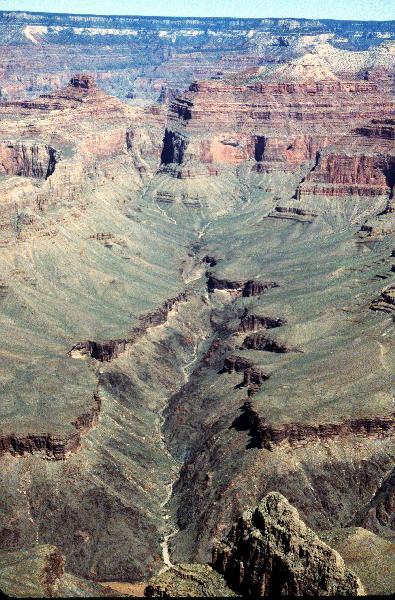
Figure 2.6: Another of the north-side tributary canyons, taken from an overlook on the West Rim Drive. You can clearly see how this tributary canyon cuts down through the Tapeats Sandstone and into the Vishnu Schist below. A bit of the Colorado River is visible near the bottom of the photo. The river's flow runs right-to-left. It certainly looks like this canyon was cut by water flowing down from the North Rim, doesn't it? Can you see any sign of the enormous rush of floodwater Austin claims came from the east (right) side of the picture? How could a torrent of water flowing east to west cut a canyon that trends north to south?
Even some of Austin's creationist colleagues acknowledge these weaknesses -- for example, see Michael Oard's article "Comments on the breached dam theory for the formation of the Grand Canyon," in Creation Research Science Quarterly, volume 30, June 1993, p. 39-46.
But perhaps most damning of all is that Austin's 'breached dam' model offers no explanation, not even a hint of an explanation, for the temples and buttes that stand far out in the Canyon. These must have been formed by the rushing lakewater if Austin is correct, for certainly three thousand years is not enough to form such massifs as the Vishnu Temple by gradual erosion. Yet the temples don't look even remotely like flash-flood relics. Their sides are not smoothed as by running water, nor are their shapes oriented toward where the water flow would have been coming from. Look again at the photograph of the Vishnu Temple, above. Or look at the photo below, which is the Vishnu Temple from another angle. Do you see any signs of erosion by large amounts of fast-moving water? The flood from Hopi and Canyonlands Lake, carrying a tremendous load of abrasive sediment, would have hit this massive butte almost broadside-on. How could the Vishnu Temple survive such punishment from a rush of water powerful enough to excavate the whole Grand Canyon in a matter of days or weeks? This is pretty hard rock, so there should still be some evidence of such massive water erosion. But there isn't any.
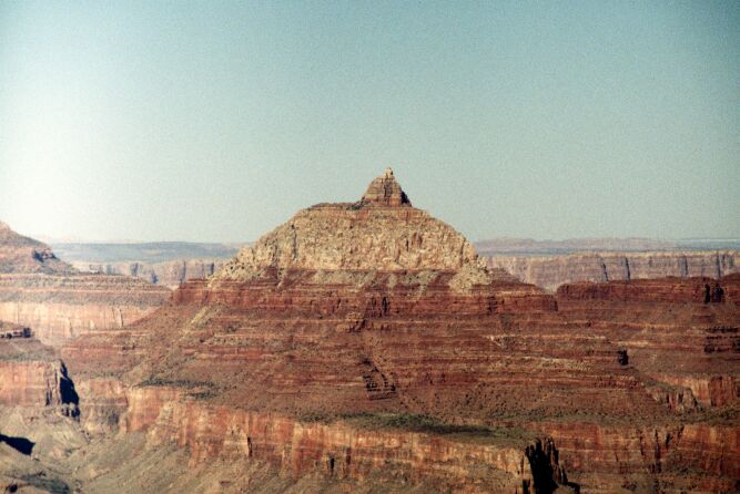
Figure 2.5: Another view of the Vishnu Temple. Again, the temple itself is Coconino Sandstone, with Hermit, Supai, and Redwall strata visible below it. This view is looking roughly northeast from an overlook on the South Rim near Grand Canyon Village.
Even some of the evidence Austin does manage to offer seems suspect. He claims that Grand Canyon does not contain the large amount of talus one would expect if it was very old, but the photograph he offers as evidence of this (Figure 5.21, p. 101) shows many talus-covered slopes in the Canyon. The only slopes in that photo that don't have talus are the very steep cliffs such as the Redwall Limestone, which is too steep for talus to form under any circumstances. This doesn't mean the argument is wrong, but it does mean that the evidence provided doesn't support the argument.
Austin tries to argue by analogy with several other sites -- Grand Coulee and Palouse Canyon in the Scablands, Loowit Canyon and the canyon of the Toutle River near Mount St. Helens. Unfortunately for his argument, the plain fact of the matter is that these other sites do not look like the Grand Canyon of the Colorado River. Grand Coulee (Austin's figure 5.11, p. 96) is a very wide, shallow valley, typical of a flash flood which tends to spread out over a wide area. Palouse Canyon (Austin's figure 5.12, p. 97) is a wide, roughly U-shaped canyon with the bottom partly filled by talus and debris, not the deep, clean V shape of Granite Gorge. Loowit Canyon (Austin's figure 5.14, p. 98) is one of the washout "canyons" cut into the ash and mud left by the May 18th 1980 eruption of Mount St Helens. Cutting through such soft material is a very different proposition from cutting through hard rock like the Coconino Sandstone and Redwall Limestone, to say nothing of the Vishnu schists and Zoroaster granites. (Remember that the rock of Granite Gorge is so hard that even the racing waters from the draining lava-dam lakes could not significantly erode it.) Finally, the crowning flaw is in Austin's use of the "Little Grand Canyon of the Toutle River" (Austin's figure 5.13, p. 97) as a parallel for the Grand Canyon. This analogy is critically weakened by the information that this "canyon" also cuts soft ash deposited by the big eruption.
Granite Gorge, Grand Canyon. The river flow direction is away from the camera. |
One of the many small stream canyons in the valley below Mount St. Helens. River flow is toward the camera. |
This is the comparison Austin wants his readers to accept. On the left is Granite Gorge. On the right is an example of the sort of mudflow-gouged "canyon" found in the valley below Mount St. Helens. There's a superficial, first-glance resemblance -- but that's all it is. The most telling difference is also the most obvious one: Granite Gorge has a deep V shape, with the river filling the entire gorge from wall to wall. On the other hand, the St. Helens canyons all have wide, flat floors within which the existing stream meanders back and forth. These resemble Palouse Canyon much more than they do the Grand Canyon.
All of this means that Austin is attempting to draw an analogy between situations that are clearly not analogous. A false analogy is both a logical and a scientific error, and it invalidates Austin's entire line of argument.
In short, while the conventional model is incomplete, it at least fits what evidence we do have. The Flood model is contradicted by much of the known evidence, and some of the "evidence" advanced to support it is fallacious to say the least. In such a situation, the usual answer is to take the "least bad" theory until something better can be found, and in this case the 'least bad' theory is clearly the conventional view. Certainly no scientist worth his salt will accept a clearly wrong theory when a better one is available.
What conclusions can we draw from all this?