Young-Earth Creationism
and the
Geology of the Grand Canyon
Text and Photographs by Jon Woolf
Part 1: The Geology of the Colorado Plateau
The first question: How was the Colorado Plateau formed?
Actually, maybe we should start one step further back: Just what is the Colorado Plateau?
The Colorado Plateau is an enormous landform that covers most of northern Arizona and much of Utah, a chunk of northwestern New Mexico, and most of far-western Colorado. More specifically, the Plateau is an enormous uplifted tableland. To the north and west it's bordered by the region called the Basin and Range; to the northeast it runs up against the Rocky Mountains; the south side borders the Mogollon Highlands; and to the east and southeast it adjoins the Rio Grande Rift. As the name says, it's a plateau whose height ranges from six to ten thousand feet above sea level, with a number of mountains that soar as high as twelve thousand feet. In general, the Plateau is highest in its central region, northernmost Arizona and southernmost Utah, and lower north and south of that area. The particular part of the Plateau that we're interested in is the Kaibab Uplift, a bulge that runs southeast to northwest across the southwestern quarter of the Colorado Plateau. The Grand Canyon slashes deep into and through the Kaibab Uplift.
The Plateau is made of many layers of sedimentary rock mixed with occasional igneous intrusions and lava flows. Most of the rocks lie horizontally, as they were originally deposited. The Plateau is a single great shallow anticline (upward fold), with no smaller folds, no overturned strata, no major thrust-faults -- in other words, there has been no recent geologic activity that might seriously distort the rock record. It's a WYSIWYG sort of geology: What You See Is What You Get, and there isn't any need for complicated thinking to unravel complicated landforms, such as there are in the Appalachians or the Rocky Mountains.
Now, what's the geology of the Colorado Plateau? That is, what's the evidence that any explanation of the Plateau needs to deal with? Thanks to the Grand Canyon and other river canyons cut into the Plateau, that's an easy question to answer. We can start at the lowest exposed level, the Inner Gorge of the Grand Canyon, also called Granite Gorge.
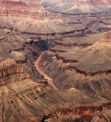
Figure 1.1: The Colorado River and Inner Gorge, as seen from Mohave Point on the West Rim Drive, South Rim. The white water in the lower center is Hermit Rapids, where Hermit Creek enters the river. The high, steep, unlayered cliffs to left and right of the river are the Vishnu Schist. The flat area visible above the Vishnu on the right is the Tonto Platform; the vertical cliff that forms its edge is the Tapeats Sandstone. The shallow slope on the far right is the Bright Angel Shale.
The Inner Gorge cuts into a thick, complex, many-layered mass of crystalline rocks. Geologists divide these rocks into two major groups. First is the Vishnu Group, which consists of metamorphic schists, gneisses, and greenstones. The Vishnu Group is estimated to be more than 40,000 feet thick in places. It contains remnants of sedimentary structures such as crossbedding, and it also contains lightly metamorphed carbonates which may be the remnants of fossilized stromatolites (mats of photosynthetic bacteria, some of the simplest lifeforms on Earth). Radiometric dates from Vishnu rocks vary between 1.725 billion years and 1.2 billion years, depending on the specific rocks tested and the method employed. A very advanced method called "neodymium isotope tracking" indicates the Vishnu rocks originally solidified around 1.8 to 2 billion years ago. (Whether or not you accept these dates as accurate isn't relevant at this point. At the moment, I'm only saying that the data exists, not whether it's right or wrong.)
Intruding into the Vishnu Group are a variety of granites that are lumped together as the Zoroaster Plutonic Complex. These include plutons (large solid masses of rock which were once magma reservoirs), dikes (vertical columns cutting upward through existing rocks), and sills (long-ranging horizontal layers forced between existing rock layers). Both the Vishnu and Zoroaster rocks are assigned to the Proterozoic Era, the "era of first life." As igneous rocks, the Zoroaster granites are relatively easy to date radiometrically; the results vary between 1.6 and 1.4 billion years.
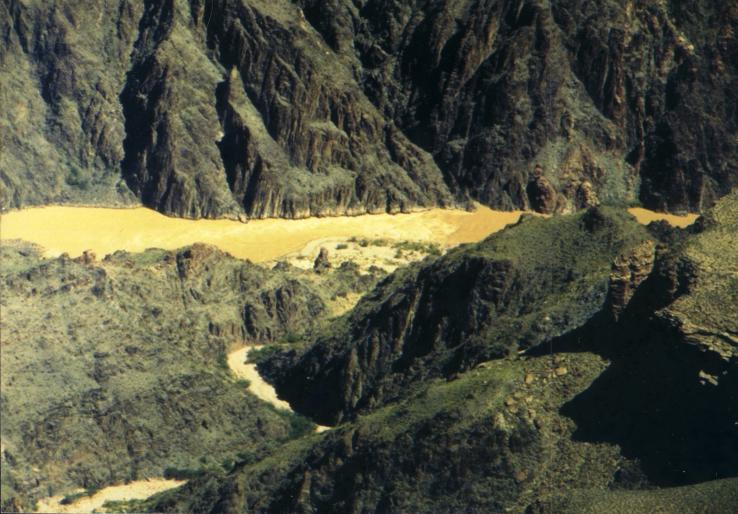
Figure 1.2: A closer look at a section of Granite Gorge. Here you can clearly see the greenish, unlayered rock which is typical of the Vishnu Group. If you look carefully at the right side of this photo, you can also see two outcrops of Zoroaster granites. One is at the riverbank on the far side. The other is the column of pinkish rock that emerges from the shadowed area in the middle foreground.
In the eastern (upriver) part of the Grand Canyon, the river does not actually reach down into the Vishnu/Zoroaster complex. Instead, it cuts through the Grand Canyon Supergroup, a set of nine rock formations that includes shales, limestones, siltstones, sandstones, conglomerates, lava flows, and intrusive igneous sills. The Grand Canyon Supergroup ranges up to 12,000 feet thick, but it is only well-exposed along the river in the eastern Canyon. In the central and western Canyon it appears in only a few places, mostly along fault lines. This odd state of affairs is explained by the fact that the layers of the Grand Canyon Supergroup lie at a noticeable angle -- about 10-12 degrees -- to the rocks above them. Look at the photograph below -- can you pick out the Grand Canyon Supergroup rocks? Can you find the contact between them and the more horizontal strata lying above them?
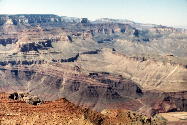
Figure 1.3: Part of the Grand Canyon Supergroup, as seen from the observation deck at Desert View. The red-purple rocks near the bottom are the Dox Formation. Above the Dox, the thick dark layer is the Cardenas Lava, topped by the many-colored Nankoweap Formation and then the bland, sandy rock of the lower Galeros Formation, all overlain by the distinctive shelf-edge of the Tapeats Sandstone. In the lower right corner you can see a bend and point bar of the Colorado River.
The Grand Canyon Supergroup is divided into nine major rock formations. The Bass Limestone, Hakatai Shale, Shinumo Quartzite, Dox Formation, and Cardenas Lava together make up the Unkar Group. Above them is the Nankoweap Formation. Then there's the Chuar Group, which includes the Galeros and Kwagunt formations. At the top of the Supergroup is the Sixtymile Formation, which occurs in only a few places. Five noticeable unconformities occur in the Grand Canyon Supergroup: Hakatai/Shinumo, Cardenas/Nankoweap, lower/upper Nankoweap, Nankoweap/Galeros, and Kwagunt/Sixtymile.
The unconformity between the Cardenas and Nankoweap formations is especially interesting because the lowermost Nankoweap includes chunks of rock that clearly came from the Cardenas Lavas below. This means that there was erosion going on after the Cardenas lava flows and before the lowermost Nankoweap Formation was deposited. Also interesting is that the Sixtymile Formation was apparently deposited during a period of tectonic (earthquake) activity; the Sixtymile rocks preserve unmistakable evidence of faulting and earthquake-triggered landslides.
There are a few fossils in the Grand Canyon Supergroup. Several different types of stromatolites (fossilized algal mats) can be found in several layers, always in rocks typical of shallow-marine deposition. In a few places there are other fossils: acritarchs, algae of several kinds, and a variety of vase-shaped microfossils which can't yet be classified. These fossils are used to assign the Supergroup rocks to the interval of time called the Proterozoic, the "age of first life." The Cardenas Lava can be dated directly using radiometric and paleomagnetic methods; the results of these tests match the stratigraphic indicators of the Supergroup's age. Rubidium-strontium (Rb-Sr) tests on Cardenas samples yield an age of 1.1 billion (1100 million) years. Paleomagnetic data indicates about the same age. Potassium-argon (K-Ar) dates on Cardenas samples yield an age of 810 million years. Keep this in mind -- 300 million years is not a small discrepancy, and it will need explaining.
Above the Grand Canyon Supergroup, we find the first of the eight major layers that form what I think of as the "Upper Canyon." This first layer is the Tapeats Sandstone. This formation can be found all through the Grand Canyon. It's always relatively flat, forms a vertical cliff at its edge, and marks the boundary between the river gorge and the Upper Canyon cliffs. It is the lowest of the horizontal layers in the Colorado Plateau. Can you see it in Figures 1 and 3? It's not hard to find. One of the nice things about the Grand Canyon is that every layer in the Upper Canyon rocks is easy to identify, even for a beginner. (Again, this is a big reason why geologists so love the Canyon: all by itself it's an introductory course to basic geology.) The Tapeats Sandstone contains a variety of trace fossils (burrows, tracks, etc.) and a few body fossils, but not enough for stratigraphic correlation. Instead, the Tapeats is assigned an age of Early Cambrian based on its position underlying the Middle Cambrian Bright Angel Shale.
Above the Tapeats Sandstone lies the Bright Angel Shale, a series of soft shales and siltstones that erodes easily and forms gentle slopes which are often covered with talus, fragments of rock eroded away from further up. The Bright Angel Shale ranges in thickness from 450 feet in the western Canyon to less than 300 feet in the eastern Canyon. Numerous invertebrate fossils, including brachiopods, mollusks, and many kinds of burrows, allow the Bright Angel to be assigned to the Middle Cambrian.
Next up is the Muav Limestone, a complex formation that consists of mixed shales, siltstones, conglomerates, and carbonates. The Muav and Bright Angel formations are complexly intertongued, meaning that the Muav was deposited directly atop the Bright Angel with no period of erosion in between. Fossil correlation supports this, showing the Muav to be from about the same time period as the Bright Angel. Like the Bright Angel Shale, the Muav Limestone is soft and easily eroded, so it's rather difficult to find when you're looking at the canyon wall. The intact layers of the Bright Angel and Muav formations tend to be buried under a lot of loose rock and rubble.
Above the Muav Limestone, things get complicated. Depending on where you look in the Grand Canyon, you can find any one of three different formations overlying the Muav Limestone. In the western Canyon, around Grand Wash, there is a thick mass of undifferentiated dolomite called the Grand Wash Dolomite, which is tentatively dated to the Late Cambrian. In the central Canyon, one finds a formation called the Temple Butte Formation, which fossils show to be of Devonian age. Farther east, the Temple Butte disappears and the Redwall Limestone, of Mississippian age, lies directly atop the Muav.
The Temple Butte Limestone is a layer of dolomitic limestone that occurs only in scattered outcrops in the eastern Grand Canyon, but becomes more common as you move west. It becomes a continuous layer between the Muav and Redwall formations somewhere around Grand Canyon Village, and continues to thicken to a maximum of about 450 feet near the mouth of the Canyon. In many places the Temple Butte fills channels cut deeply into the underlying Muav Limestone. Fossils present in the Temple Butte rocks show it to be from the Middle to Late Devonian. This means that the Muav/Temple Butte contact marks a gigantic unconformity, and there are no rocks of Ordovician, Silurian, or Early Devonian age in the Grand Canyon.
The Redwall Limestone is a thick, extremely hard layer of limestone found throughout the Canyon. In some places it overlies the Temple Butte Formation; in others it lies directly atop the Muav Limestone. Everywhere its appearance is unmistakable: towering vertical cliffs five to eight hundred feet high, stained red by minerals washing down from the Supai Group above it. At the top of the Redwall we find something very interesting: a type of topography called "karst limestone," which often includes caves and sinkholes. Today, karst topography occurs only in limestone that's above sea level and thus exposed to air and running water. Based on its fossils, the Redwall is assigned to the Mississippian period.
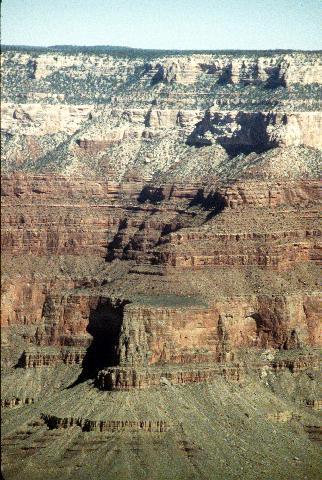
Figure 1.4: The upper part of the north canyon wall, from an overlook along the West Rim Drive. To give this image some scale, you're seeing something on the order of 3000 vertical feet of canyon wall here. From bottom to top, this photograph shows the Muav, Temple Butte, Redwall, Supai Group, Hermit, Coconino, Toroweap, and Kaibab formations. The Redwall Limestone is the vertical, buffy orange cliff about a quarter of the way up; the Temple Butte Limestone is the slightly wider, rougher 'step' at the base of the Redwall. Work down from there to find the Muav formation, then up to find the others. Can you pick out the four distinct formations that make up the Supai Group?
Above the Redwall we have a surprise waiting -- literally. In various places in the western Canyon, one finds scattered outcrops lying atop the Redwall Limestone which do not belong either to the Redwall or the overlying Supai Group. These were given a name only in 1985: the Surprise Canyon Formation. This formation consists of a mixture of carbonates (limestone and dolomite) and clastic rocks (that is, rocks made of particles cemented together, like sandstone and shale). In many places, the lowermost layer of the Surprise Canyon Formation is a conglomerate that includes chunks of Redwall rock. Some of these chunks even have Redwall fossils in them. (This is a perfect example of what geologists call reworking. Though these fossils appear in the Surprise Canyon Formation, they are actually Redwall fossils and are useless for dating the Surprise Canyon rocks.) The Surprise Canyon rocks occur in what are clearly shallow, broad valleys cut into the Redwall Limestone. Geologists have been able to reconstruct a partial drainage basin for the Surprise Canyon rivers; this indicates a roughly east-to-west direction of flow. The Surprise Canyon rocks also include a variety of fossils of their own, both plants and marine invertebrates. These date the Surprise Canyon Formation to the Late Mississippian, with the uppermost level possibly being from the earliest Pennsylvanian.
Above the Redwall and Surprise Canyon formations we find the Supai Group, a distinctive sequence of four formations. From bottom to top, these are the Watahomigi, Manakacha, Wescogame, and Esplanade. Based on the fossils found in them, the first two are assigned to the Early Pennsylvanian; the Wescogame is Late Pennsylvanian; and the Esplanade is Early Permian. These layers are a complex series of siltstones, sandstones, and conglomerates marked by a stair-step series of relatively steep slopes and a rich, vivid red coloring that comes from the presence of large amounts of iron-rich quartz in the rocks. More interesting, many layers in the Supai Group show evidence of being eolian (wind) deposited, not water-deposited. The eolian and water-deposited layers are intermixed throughout the entire several hundred feet of the Supai Group. Also interesting is that the lowest level of the Supai Group is a conglomerate made of rock that was eroded from the underlying Redwall Limestone. In other words, the Redwall/Supai contact is clearly the remnants of an eroded surface. Further evidence of a break in deposition below the Supai Group is provided by the Surprise Canyon Formation: in several places, the Surprise Canyon/Supai contact is marked by an angular unconformity.
Above the Supai Group lies the Hermit Formation, a thick set of rather nondescript siltstones, mudstones, and sandstones that are generally soft and easily eroded, so that they form gentle slopes. Fossils found in the Hermit Formation allow geologists to assign it to the Late Permian period.
Next up is the Coconino Sandstone, another formation which is easily recognized anywhere in the Canyon as a thick layer of very hard, glaring white sandstone which forms steeply sloped cliffs. On closer inspection, the Coconino shows intricate crossbedding patterns that strongly resemble the patterns found in desert sand dunes. Fossils found in the Coconino show it to be from the Late Permian.
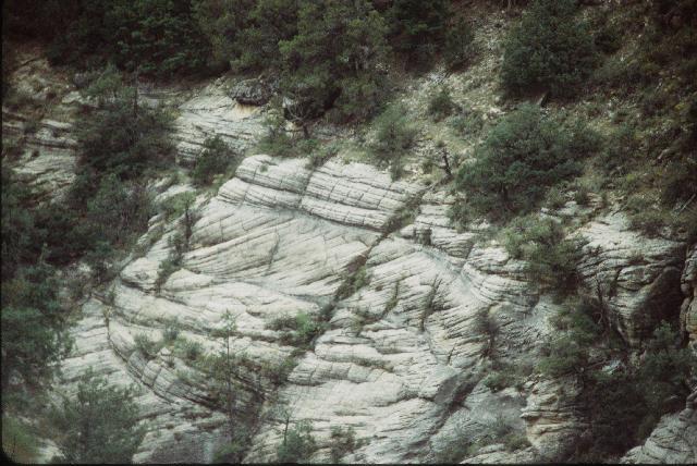
Figure 1.5: The Coconino Sandstone exposed in one side of Walnut Canyon, about fifty miles south of Grand Canyon. This photograph clearly shows the crossbedding that characterizes this layer of rock. Note the three distinct types of bedding that are present: the more or less horizontal bedding at the top, the strongly upward-sweeping layers in the middle, and the sort of lens-shaped area of downward sweep in the lower left, which interrupts the upward-sweeping beds.
Above the Coconino is a layer called the Toroweap Formation. This is a complex set of sandstones, limestones, and dolomites, recognizable mainly by the way that it forms a steep slope covered with vegetation. Many of the Toroweap sandstones are crossbedded, like the Coconino Sandstone below it. Also like the Coconino, the Toroweap is dated to Late Permian times.
Finally, both the North and South Rims of the Grand Canyon are formed by the Kaibab Formation, a complex mix of limestones, dolomites, cherts, and sandstones that was deposited in shallow water and dates to the very latest Permian.
Almost as a postscript, there are a number of lava flows in the western Grand Canyon that flow over the Rim and down into the Canyon. These flows all emanate from fissures or volcanic cones in the Kaibab Volcanic Field. They are very recent and relatively fresh. K-Ar dates from individual lava flows indicate ages ranging up to about 1.5 million years (middle Pleistocene). A 1974 study that included samples from several lava flows produced an Rb-Sr date of around 1.2 billion years. In 1992, Steve Austin of the Institute for Creation Research repeated the 1974 finding, when whole-rock samples taken from five different lava flows produced an apparent Rb-Sr date of 1.3 billion years. As with the discordant dates on the Cardenas lavas, this discrepancy in dates between the Cardenas and the recent lava flows is a significant piece of evidence that needs explaining.
Whew!
Well, that's it: bottom to top, a short introduction to the rock layers that are exposed within the Grand Canyon. These are the bare, basic facts that need to be accounted for by any theory that claims to explain how the Colorado Plateau formed. There's a lot more that could be said about the Plateau rocks; for example, elsewhere on the Plateau one can find more rock layers overlying the Canyon strata: the Moenkopi, Estrada, and Chinle rocks, all of Trassic age; the Morrison and Navajo formations, of Jurassic age; the Dakota Sandstone, of Cretaceous age; and other layers that range up into the Cenozoic. However, it would take a book to say it all, and I wanted to restrict this article to the Grand Canyon alone.
Now, how do our two opposing scenarios, Young-Earth Creationism and conventional geology, explain the geology of the Colorado Plateau?
The Creationist Theory
The creationist case for the formation of the Colorado Plateau rocks is best made by Steven A. Austin of the Institute for Creation Research and his colleagues in the book GRAND CANYON: MONUMENT TO CATASTROPHE. Austin is a young-Earth Creationist who holds that the planet and all its rocks were created as described in Genesis 1 and 2, no more than 10,000 years ago, and that the fossil record and most modern geography is a result of the Biblical Flood, which took place 1600 years after the Creation. In GRAND CANYON: MONUMENT TO CATASTROPHE, Austin and his colleagues attempt to develop an explanation for the Colorado Plateau and the Grand Canyon in the context of young-Earth Creationism and Flood Geology.
In Austin's view, the Vishnu Complex and Zoroaster Complex represent Creation rocks -- that is, rocks made during Creation Week. The Vishnu rocks were created on Day 1 of Creation Week, then the Zoroaster intrusions and metamorphism took place on Day 3.
The Grand Canyon Supergroup is made of sediments that were deposited and lithified (turned to stone) late in Creation Week and in the 1600 years between the Creation and the Flood (Austin p.66). Rock structures in the Shinumo Quartzite in particular are interpreted as showing both sediment deposition and tectonic (earthquake) activity, which Austin says probably happened on day 3 of Creation Week. (Austin p. 64) Austin also sees the essentially marine nature of the Grand Canyon Supergroup rocks, and the presence of stromatolites in those rocks, as evidence that the area was covered by a shallow sea before the Flood.
Austin interprets the entire 4000+ foot thickness of the Paleozoic strata (Tapeats to Kaibab) as having been deposited during the "early Flood." The Great Unconformity marks the onset of the Flood: fast-moving waters that caused massive erosion and scoured the pre-Flood landscape (or seascape) nearly flat. It's well known that fast-moving water can carry a large load of sediment, and as the water slows, the sediment begins to fall out of suspension. Large rocks fall first, then pebbles and sand, and finally very small particles like silt and clay. Austin sees the progression of particle size from the Tapeats Formation through the Bright Angel Shale and the Muav Limestone as representing the early stages of the Flood, as the water slowed and sediment came out of suspension and formed into layers. First came sand, to form the Tapeats Sandstone, then mud and silt to form the Bright Angel Shale, and finally chemical deposition of carbonates formed the Muav Limestone.
Austin describes the Grand Wash Dolomite but does not tie it into his Flood model. He sees the disconformity below the Temple Butte Limestone as being the remnants of a sort of backwater in the Flood's advance. The waters became slower and shallower, allowing bottom currents to form and eroding soft channels into the tops of the Muav and Grand Wash rocks. Austin also describes the Temple Butte Limestone itself, but gives no specifics on how it formed. There is only a vague indication that he thinks it was deposited in much the same way as the Muav Limestone.
Austin gives no real explanation for the Temple Butte/Redwall disconformity, other than suggesting that submarine erosion might account for it better than the traditional geologic picture does.
Austin discusses the Redwall Limestone at some length. I'm not sure I can properly summarize his ideas on the Redwall; perhaps it would be best to simply quote him:
"Creationists might suppose that a source of pure calcium carbonate sediments, to the west, was introduced over the Canyon at the same time the Flood waters became hot from the 'fountains of the great deep.' Coarse-grained carbonate detritus (organic and inorganic) brought in by Flood waters, would have mixed with directly precipitated, fine-grained calcite and dolomite from hot water. Chert also may have been deposited from hot water as a silica gel, which rapidly lithified. Rapid accumulation of lime mud is demonstrated by fossils of crinoid heads (a fossil structure which breaks apart quickly after death), by oriented nautiloids (a marine animal resembling a squid which show current action during deposition), and by enormous cross-bed sets up to 30 feet thick (described in Chapter 3)." -- Austin, Grand Canyon: Monument to Catastrophe, p. 72
It's also hard to tell just what Austin thinks of the disconformity at the top of the Redwall Limestone, and the Surprise Canyon Formation that fills a number of channels in the top of the Redwall. It appears from his discussion of the Redwall/Supai disconformity (pp. 48-9) that Austin thinks the Flood waters in this area became very shallow after the Redwall Limestone was deposited. Shallow, fast-moving water currents then eroded channels into the top of the Redwall. Some time later, the Surprise Canyon rocks were deposited into these channels. Austin's discussion of this disconformity appears to suffer from some confusion between channels and caves made in the Redwall Limestone before the disconformity was formed, and caves and vertical pipes formed after the whole mass of rock had been deposited.
Austin says that the complex crossbedding in a number of places within the Supai Group's four formations indicate it's made of marine-deposited shales and sandstones. Some of the sandstones may have been oxidized and cemented by hot water. Austin says specifically that the sandstones of the Supai Group appear to have been deposited as "sand waves moved in deep water by fast currents." (Austin p. 73)
Austin doesn't give any clear explanation is given for the Hermit Formation, but he does point out that the uniformity of the particle sizes and apparent lack of any deeper channels argues for marine deposition rather than the river-delta scenario used by conventional geologists. It appears that in his view, the Hermit Formation is simply another layer of rock made of sediments deposited by the waters of the Flood.
Austin interprets the enormous mass of the Coconino Sandstone as marine-deposited "sand waves," brought from the north by water at least a hundred feet deep and moving at more than three feet per second (that's not particularly fast; three feet per second is a bit over two miles an hour). As the Hermit/Coconino contact is amazingly flat, this movement of water must have been extremely widespread, more or less continous and consistent in depth and velocity over hundreds or thousands of square miles. The sandy limestone of the Toroweap Formation was then deposited under water after currents churned up the top of the Coconino layers and mixed it with fresh lime and sand coming from a source to the west. Finally, the Kaibab Limestone is another Flood-deposited layer, similar to the Toroweap, containing large crossbedded sandstones deposited by sand waves mixed with siltstones and limestones deposited by other processes. Austin seems to think that the Kaibab Formation marks the height (or depth) of the Flood, when the waters were deepest and before they began their retreat. Layers higher up the Plateau, such as the Chinle, Moenkopi, and Morrison, represent later Flood deposits made while the waters were retreating.
Austin sees the lava flows in western Grand Canyon as post-Flood deposits, formed in the 4000 years since the Flood. In a paper published in the ICR's magazine Impact, Austin argues that the lava dams of the western Canyon and associated lakes could have formed and broken rapidly, within only a few years.
Austin devotes an entire chapter to the results of his "Grand Canyon Dating Project." This study involved tests on samples from five different lava flows in the western Grand Canyon. When tested by the rubidium-strontium (Rb-Sr) isochron method, the five samples indicated an approximate date of 1.3 billion years. However, the Cardenas Basalt in the Grand Canyon Supergroup has been dated by the same method at right around 1 billion years. Obviously, lava flows on the Rim cannot be older than rock layers buried deep in the Canyon! Austin uses this study and the discrepancy between Rb-Sr and K-Ar dates of the Cardenas lavas as the basis of his decision to throw out any and all data on the age of Grand Canyon rocks derived from radiometric dating methods.
The Conventional Theory
The current orthodox view of the Colorado Plateau is completely and concisely given in GRAND CANYON GEOLOGY, a collection of journal-quality articles about the Plateau and the Canyon published in 1990. The articles in this book build a picture of the rocks of the Colorado Plateau as a record of a long series of events in the planet's history. 'Way down at the bottom of the Plateau's geologic column, the Vishnu Group and Zoroaster Complex are part of what geologists call "basement rock," the foundation of the entire North American continent. The Vishnu Group's schists and gneisses are seen as metamorphosed remains of a variety of sedimentary and extrusive igneous rocks deposited in the Proterozoic, almost two billion years ago. While much of the Vishnu rocks' original features were destroyed or distorted by the metamorphism, what's left is consistent with formation in and around an ancient volcanic island arc that was later sutured onto the base North American craton (proto-continent). Possibly at the same time as the suturing, these ancient rocks were folded and metamorphosed into the modern Vishnu Group. A variety of geochemical and radiometric data indicates that the Vishnu metamorphism took place in two stages: a period of compression (folding) at just over 1.7 billion years ago, then a period of heating at about 1.68 to 1.65 billion years. The metamorphism was probably part of an orogenic (mountain-building) event, meaning that the modern Vishnu Group was once the roots of a major ancient mountain range.
All throughout the metamorphic activity, and possibly related to it, the first wave of Zoroaster granites were intruding into the Vishnu rocks. A second wave of intrusive igneous activity took place about 1.5 to 1.4 billion years ago, and this resulted in the younger Zoroaster intrusions.
After the Zoroaster activity there was a long period of erosion, during which the ancient mountain range was worn away. By about 1.1 billion years ago, the whole region was under water. At this time sediment deposition started again, resulting in the rocks of the Grand Canyon Supergroup. The lower Bass Formation, lowest formation in the Supergroup, records a west-to-east sea transgression. The sea was probably fairly shallow, judging from the repeated appearance of shoreline features such as mudcracks and ripple marks. From there on up, the Grand Canyon Supergroup rocks record a series of transgressions and regressions, indicating the area was low and flat, and that as the sea rose and fell, the environment cycled repeatedly between coastal plain, tidal flats, and shallow offshore shelf. In particular, the Cardenas Lavas at the top of the Unkar Group were flowing at a time when the area was at or just below sea level. After that, the Cardenas/Nankoweap unconformity indicates a substantial period of erosion, when the surface was above sea level. Then the Nankoweap and the Chuar Group were deposited. After the Sixtymile Formation (uppermost Chuar) was deposited, the whole Grand Canyon Supergroup was tilted by tectonic activity and then eroded nearly flat. Some faulting also occurred during this period, dropping large chunks of the Grand Canyon Supergroup downward . All of this activity was finished before 600 million years ago. The 300-million-year discrepancy between Rb-Sr and K-Ar dates for the Cardenas Lavas is not fully explained; the best explanation offered so far is that the potassium-argon date indicates a period of mild heating which was enough to drive off argon and reset the potassium-argon clock, but not enough to disrupt the rubidium/strontium ratio. This may correspond to the faulting and other tectonic activity which is recorded by the Sixtymile Formation, but that's a very tentative idea.
The Tapeats Sandstone marks the beginning of the next wave of deposition. The Tapeats was deposited on the bottom of a shallow sea. Then the Bright Angel, Muav Formation, and Grand Wash formations were deposited more or less continuously, with only brief breaks if any at all. These rocks were probably deposited in shallow coastal waters. An elementary fact of geology is that water depth can be roughly estimated by the type of rock being formed: sandstone forms close to shore, siltstone and mudstone farther out, and deep water is marked by organic limestone. Very deep water produces inorganic limestone. The two types of limestone can usually be distinguished by whether or not they contain fossils. Thus, if you see sandstone, then siltstone atop it, then limestone atop the siltstone, you know that the water was getting deeper as time went on. If the rock sequence is reversed, from imestone to sandstone, you know the water was getting shallower. In the Bright Angel-to-Muav sequence, the recurring shallow-to-deep-to-shallow rock sequence show that the sea rose and fell somewhat, but was never very deep.
After the Muav and Grand Wash layers were deposited, the area was apparently above sea level for a long time, so that either no rock at all was deposited, or any that was deposited was later eroded. This erosion removed all evidence of the Ordovician, Silurian, and lower Devonian periods. Somewhere around the middle of the Devonian the sea rose (or the land sank) again, resulting in renewed deposition of sediments that became the Temple Butte Limestone. Judging by the types of fossils found in it, and the characteristics of the rock itself, the Temple Butte formation was probably deposited in a subtidal (that is, just offshore) marine environment. The sea then receded again, and much of the Temple Butte was eroded away. When the sea rose again, the Redwall Limestone began to form. After the Redwall formed, another sea regression resulted in the Redwall being above sea level for a brief period as a coastal plain, at which time the uppermost Redwall was eroded into karst topography and the rocks of the Surprise Canyon Formation were deposited in the riverbeds and tidal channels of a vast, far-reaching estuarine system.
During the lower and middle Permian period, the Colorado Plateau region underwent a complex series of sea transgressions and regressions, coupled with mild uplifts and a variety of other geologic activity. The Supai Group is the result of all this activity: a complex series of redbeds, primarily sandstones but also including mudstones, shales, and carbonate rocks. As you ascend through the Supai Group, its beds grade from shallow marine rocks into eolian deposits, formed by winds that brought vast amounts of sand and silt from somewhere to the northwest. Thus, the Supai Group records a period when the area transformed slowly from a fertile coastal plain to a desertified coastal plain, and shifted back and forth between shallow marine and coastal plain many times as the sea advanced and receded.
Next above the Supai Group, the Hermit Formation is a thick layer of sandy siltstones and silty sandstones that were most likely deposited by stream activity in an otherwise dry coastal-plain environment. Thus, the Supai and Hermit together record a slow sea regression, which left arid, desert landscape behind it.
There's not much doubt in geologists' minds about the nature of the Coconino Sandstone: it's a massive layer of lithified sand dunes, deposited in an arid desert environment. The Coconino records a time when the Colorado Plateau region was the southern edge of a vast dune sea, similar to the modern Rub' al Khali, which reached as far north as Montana.
The Toroweap Formation, above the Coconino, is complex and difficult to fully understand. While it's all considered one formation, the Toroweap changes both vertically (top to bottom) and laterally. Over its full extent it includes shallow tidal deposits, supratidal deposits, stream deposits, and some eolian deposits. This shows that the Toroweap records a time of complex environmental change, when a sea to the west advanced eastward and retreated back westward several times. However, the seashore never reached the easternmost parts of the Plateau. That region was left as a dry coastal plain, and there the Toroweap Formation consists of eolian sandstones almost indistinguishable from the Coconino Sandstone.
At the top of the Grand Canyon, the Kaibab Formation records a time when the sea rose and fell repeatedly, but never by very much, so that the environment went back and forth between tidal and shallow-marine.
Sometime long after the Kaibab Formation was deposited, the entire region was gently uplifted in a massive bulge, elevating it from near sea level to its present altitude of more than 7000 feet.
Very recently, long after the uplift was completed and the canyon had formed, a volcanic field developed north of the canyon. Fissure and cone eruptions both appeared in this field, pouring more than a hundred basaltic lava flows over the North Rim and into the Canyon. At least a dozen of these flows created lava dams, resulting in large lakes forming upstream until the water overtopped the dams and was able to begin eroding them away. The K-Ar radiometric dates from individual flows (up to 1.5 million years) are accepted as accurate; the 1.3 billion year date derived from Rb-Sr testing on samples from several flows is considered an example of a false isochron caused by the fact that the samples were taken from flows that occurred at different times and came from different parts of the deep magma reservoir that fed the volcanic field. If the 1.3 billion-year "age" means anything at all, it's the age of the magma reservoir itself, the time at which that particular mass of molten rock first forced its way up from the mantle into the crust.
In all cases, the fossils found in each rock layer are typical of the organisms living in the area at the time that layer was deposited.
Comparison:
Which explanation best matches the facts?
The creationist explanation, as given by Austin, seems plausible on the surface. Unfortunately, it disintegrates rather rapidly under detailed examination. The problems start with Austin's casual dismissal of the radiometric data. His "Grand Canyon Dating Project" is fundamentally flawed in a number of ways, which are explored by Chris Stassen in his talk.origins article "A Criticism of ICR's Grand Canyon Dating Project." Since Austin's attempt to discredit the radiometric dates fails, he is left with no explanation at all for that data. This is not a small problem -- whatever the real meaning of the radiometric data, it does exist and it does have to be given a plausible explanation.
In adopting the standard "the Flood did it" explanation used by most young-Earth Creationists for the fossil record, Austin seems to either miss or deliberately gloss over a number of rather glaring questions that this hypothesis raises. For example:
- Why are there no fossils of advanced organisms in the pre-Flood rocks of the Grand Canyon Supergroup? Before the Flood, there were supposedly countless animals and plants and other lifeforms around. It seems only reasonable to suppose that some of these organisms would have been buried and fossilized, yet there is no trace of any of them in the Grand Canyon Supergroup rocks. Those rocks contain only fossils of extremely primitive lifeforms, like stromatolites and acritarchs.
- How is it possible that the Redwall Limestone became so hard that it remains a rigid, nearly vertical, extremely erosion-resistant wall today, yet its top was so soft that substantial erosion could take place within hours after it formed?
- How is it possible that "sand waves" deposited rapidly, by fast-moving and turbulent water, could preserve such delicate features as footprints?
- Austin's Flood model says that the 4000 feet of rock between the Great Unconformity and the Rim were deposited in the 150 days between the onset of the Flood and its peak (Austin, p. 77-8). Actually, there would have had to be more than 4000 feet deposited, because of the several unconformities which represent eroded surfaces. This works out to almost thirty feet of sedimentary rock deposited every day. Yet all throughout the Canyon rocks, we find structures that take time to form, such as burrows. What sort of animal would take the time to dig a burrow when it will be under ten feet of sediment before it finishes? We also find a great many trace fossils, including many trackways. Why don't we ever find body fossils associated with trackways, where the animal that made the tracks was caught and preserved by the rapidly accumulating sediments?
- Why are there no fossils of any large Mesozoic or Cenozoic animals anywhere in the Grand Canyon rocks? All Grand Canyon fossils are typical of the layers in which they're found. Nowhere do we find a single out-of-order fossil. The Grand Canyon rocks are all Paleozoic, and all have only Paleozoic fossils in them. There are no fossils of Mesozoic sea animals, such as ichthyosaurs and plesiosaurs. There are no fossils of Cenozoic sea animals, such as whales and seals. There are no modern fish species, only Paleozoic ones. I'm not saying this selectivity in the fossil record can't be explained by the Flood model. I'm saying that Austin doesn't offer any explanation. In fact, he doesn't even mention the problem at all. The absence of any discussion of the topic is certainly a mark against Austin's model.
- What about the rock layers that Austin doesn't tie into his Flood model, like the Grand Wash Dolomite and the Surprise Canyon Formation?
Austin's explanation for the Tapeats-Bright Angel-Muav sequence looks plausible at first glance, but founders on closer examination. Recall that Austin explained these as a sequence laid down by the initial surge of floodwaters, with sand settling out first as the Tapeats Sandstone, then silt as the Bright Angel Shale, then fine sediments and carbonates as the Muav Limestone. Unfortunately for Austin, despite its name the Bright Angel Shale includes several thin layers of coarse-grained conglomerates and pebbly sandstones. Further, there are sequences in the Bright Angel where the grains get coarser, not finer, as you move upward. The Muav Limestone also includes many layers of shale, siltstone, and even some pebbly sandstones, indicating that something rather more complex than the simple picture Austin paints was going on when this rock was laid down.
Another problem: Fossils found in the Tapeats, Bright Angel, and Muav formations include the clamlike creatures called brachiopods. Like many other Cambrian animals, brachiopods were bottomdwellers, which anchor to a selected spot when they're still larvae and thereafter grow in place. (We know this is true because some species of brachiopods are still alive today in deep-sea environments, and their life cycle has been thoroughly studied.) The same question that was asked about burrows comes to mind again: how could a fixed, bottom-dwelling animal find the time and the food to grow to full size while it was under a steady stream of settling sediment? If it anchored itself at dawn, it would be under fifteen feet of sediment by nightfall.
Austin also fails to give any adequate explanation for the eroded surfaces present between a number of Grand Canyon formations. The most significant of these is the interval between the Redwall Limestone and the Supai Group, which in places is marked by the Surprise Canyon Formation. In places there is a distinct angular unconformity between the Surprise Canyon layers and the overlying Supai layers, indicating that the region was very gently tilted after the Surprise Canyon rocks were deposited and before the Supai was laid down. The Surprise Canyon Formation itself poses a problem for Austin's scenario. If Austin is right, the presence of Redwall fragments and fossils in the lowermost Surprise Canyon rocks implies the Redwall was soft enough to be rapidly eroded to create the channels which the Surprise Canyon Formation fills, yet hard enough for chunks of Redwall rock to hold together after this occurred. This appears contradictory, to say the least.
Austin goes to some length to explain how the enormous crossbeds typical of the Coconino Sandstone could have formed underwater, using a concept he calls "sand waves." He relates these to the depth of the water: the original wave was much larger than the thickness of the crossbedding, and the height of the sand wave is one-fifth the depth of the water. So by Austin's own argument, sand waves big enough to create thirty-foot crossbedding, such as in the Coconino, require some pretty deep water. Keep in mind that the Flood model requires all this to be deposited in a matter of days. Under so much water, and such a deluge of sand, how could an animal stay on the bottom and walk on the same layer of sand long enough to create the trackways which are also found in the Coconino Sandstone?
Finally, throughout Austin's discussion of the Grand Canyon rocks, in Chapters 3 and 4 of his book, there are two general weaknesses that appear over and over again. One is that he greatly oversimplifies the lithologies of the Grand Canyon rock layers, skipping over details that could cause problems for his Flood model. GRAND CANYON GEOLOGY is the finest single extant reference for the Grand Canyon rocks. In fact, Austin used this book as a reference when writing his own account of Grand Canyon's rocks. I grant that some simplification was necessary, as GRAND CANYON GEOLOGY gets very technical in spots, but Austin did not merely simplify the information. He selectively edited it, including only information that would strengthen his case and none that might weaken it.
The second general weakness of Austin's case is the enormous number of ad hoc hypotheses he introduces. Ad hoc is a Latin phrase that translates roughly as "for this purpose." In the physical sciences, it refers to a hypothesis introduced solely to explain an otherwise unexplainable datum. An ad hoc hypothesis makes no predictions; it cannot be tested; it's added simply because the hypothesizer needs an answer and can't find one within existing theories and hypotheses. The "epicycles" used to make the Ptolemaic theory of planetary motions work are a perfect example of an ad hoc hypothesis. Introducing an ad hoc hypothesis is a sign of weakness in a theory. Experience has shown over and over again that the more ad hoc hypotheses you need to make a theory work, the more likely it is that the whole theory is wrong.
Austin uses a great many ad hoc hypotheses to make his Flood model work. The "sand waves" which he uses to explain the crossbedding in the Supai Group and Coconino Sandstone are a good example. This idea is introduced only because Austin needs to explain the dunelike crossbedding of these sandstones within his Flood model. Another example is the many casual references to depth and velocity of Flood waters; these are changed as necessary to account for the features being discussed at the moment, with little apparent regard for the overall model. Consider the paradoxical contrast between sand crossbeds that last long enough to preserve trackways and sand crossbeds that are being deposited by widespread, powerful water currents at the rate of many feet per day. No matter what your viewpoint, it is not a good sign when your 'explanations' for different features of the same rocks start contradicting each other!
In short, the Flood model for the origins of the rocks of the Colorado Plateau is internally contradictory and inconsistent with the actual data. It doesn't deal with all the available data, and it can't even adequately explain the data it does deal with. It simply doesn't work. So it seems safe to say that Austin's Flood model is definitely wrong. Furthermore, most of the objections raised here against Austin's particular model can also be raised against any model that attempts to explain the rock record as having been formed rapidly and recently. So we can reasonably conclude that any young-earth interpretation of the Colorado Plateau is doomed to failure.
On the other hand, the orthodox interpretation of the Colorado Plateau fits the facts pretty well. We've already concluded that the Colorado Plateau cannot be as young as the young-Earthers claim it is. Given that, it seems reasonable to also conclude that the Plateau is as old as conventional theory says it is. There are a few holes and gaps in the conventional theory; the one that stands out the most is the discordant Rb-Sr and K-Ar dates for the Cardenas Lavas, and even that has a tentative explanation. The anomalous dating of the Pleistocene lava flows is readily explained as a false isochron, something well known to geologists and the primary reason why geologists insist that samples for radiometric dates must all come from the same unit of rock. The orthodox explanation is also consistent with the rest of modern geology, with the Colorado Plateau rocks matching rocks from elsewhere in appearance and lithology. The fossil record is also consistent with the rest of the geologic record, with only primitive, simple fossils in the Precambrian rocks; more advanced fossils typical of their periods in the Paleozoic upper canyon strata; faults, folds, landslides, lava flows, and other features which can readily be explained by well-understood geologic processes.
Now, what about the Grand Canyon itself?